
Nebraska Map
|
 |
 |
Where Is Nebraska?
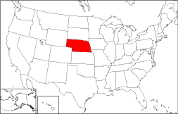
The State of Nebraska, shown in red on this map, is bounded by South Dakota on the north and by Kansas on the south. It is bordered by Iowa to the east and by Wyoming to the west. Nebraska is bounded by the State of Missouri on the southeast and by the State of Colorado on the southwest.
Nebraska Maps
Nebraska is the 15th largest state in the United States, and its land area is 76,872 square miles (199,098 square kilometers). Several of Nebraska's 93 counties are named after tribes like the Cheyenne and the Pawnee that once inhabited the state's vast grasslands. This Nebraska map site features road maps, topographical maps, and relief maps of Nebraska. The detailed, scrollable road map displays Nebraska counties, cities, and towns as well as Interstate, U.S., and Nebraska state highways. The pannable, scalable Nebraska street map can be zoomed in to show local streets and detailed imagery.
Nebraska Highway Map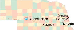 Click on the highway map thumbnail
to view a scalable Nebraska road map. |
NE Topo Map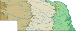 Click map to enlarge.
|
NE Relief Map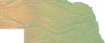 Click map to enlarge.
|
The detailed Nebraska map and the regional Nebraska map display cities, roads, rivers, and lakes as well as terrain features. The detailed map shows only the State of Nebraska, while the regional map shows Nebraska and the surrounding region.
Nebraska Infrastructure > Nebraska Airports
In 2005, the population of Nebraska was estimated at 1,758,163, which is about 22.9 people per square mile. In 2010, Nebraska's population rose to 1,826,341 people. More recently, in the 2020 census, the Nebraska population was 1,961,504. Interstate highway I-80 crosses the state from east to west. The major Nebraska airports are Eppley Airfield in Omaha and Lincoln Airport.
Nebraska Topography
Nebraska is derived from a Native American word meaning "flat water", referring to the Platte River. Nebraska's terrain rises gradually from the prairies in the east to the foothills of the Rockies in the west. The land is drained primarily by the Platte River. Chimney Rock National Historic Site, located along the Oregon Trail, is visible from miles away. Other Nebraska landmarks include the Scotts Bluff and Agate Fossil Beds National Monuments. For Nebraska travel and tourism information, visit the official Nebraska tourism site and Nebraska Atlas.
Other Maps of Nebraska
This Nebraska reference map shows major cities, roads, railroads, and physical features in Nebraska.Several map publishing companies offer printed maps of Nebraska. For example, Omni Resources offers several maps of Nebraska that feature points of interest, airports, and parks, as well as selected local attractions and insets of major Nebraska cities.
All rights reserved.
Certain maps hereon are © Map Resources or Digital Wisdom.
To facilitate browsing, certain external links will open in new windows.
Nebraska-Map.org Editor, State Maps, PO Box 828, Barnegat, NJ 08005.